To Malawi in a Ford Fiesta
Sometimes living life on a student budget drives one to do things a little out of the ordinary in the name of travel and exploration. One of the university societies that has inspired and challenged me the most is the University of Cape Town’s Mountain and Ski Club.
It is one of the largest mountain clubs in Africa, second only to the Cape Town branch of the Mountain Club of South Africa. One of its core philosophies is to encourage and support its members in the exploration of the diverse and exquisitely beautiful mountain ranges of the southern African subcontinent.

Above: Disa erubescens. Photo © Zoë Chapman Poulsen.
It is with this in mind that we gathered together to plan the trip of a lifetime to hike Mount Mulanje near Blantyre in Malawi. Despite the distance from the Mother City of more than 3,000 km, flights are notoriously expensive and were far beyond our shoestring budget. Twenty-four hours on a bus from Johannesburg was also not an appealing option.
The solution was to drive up there in a friend’s car, none other than a humble Ford Fiesta. Recently some writers from Getaway Magazine undertook the same journey in a Mini. If they could do it then what should stop us from taking on the challenge?
Our schedule was certainly punishing as we only had four days to get to Blantyre from Cape Town. The first leg of the journey took us across the Karoo Desert to Johannesburg: a journey of 1,400 km or 16 hours. We left Cape Town on a balmy January night at 2 am in the morning and began the long drive north-eastwards.
Dawn broke with the Mother City far behind us, with the warm early morning glow of the sun rising over the dusty plains of the Karoo Desert. Doggedly we plodded onwards and by nightfall that evening we arrived in the vast metropolis of Johannesburg. Midsummer brought intense thundershowers typical of Highveld weather, sometimes raining so hard it was impossible to see where we were driving. It was with great relief that we arrived at last at Mbizi Backpackers in Boksburg.

Above: Cleome densifolia. Photo © Zoë Chapman Poulsen.
The next morning we left early with our sights upon the border post and Zimbabwe’s capital city of Harare. We made good time and thanks to an excellent team effort made it complete with our trusty steed and all her paperwork through Beitbridge’s usual chaos over the border. As we drove northwards the landscape changed with beautiful granite inselbergs surrounding us as we headed north on an excellent road albeit with the odd pothole.
We made such good progress that we encountered our first delay, which involved being stopped by the local police for “speeding in a built up area”. Our crime was actually travelling at 65 kph past about three rondavels that were hidden far away from the road behind thick vegetation. However, we weren’t in the mood to argue and settled the modest on the spot fine to get on our way as quickly as possible. There was still a long way to go.
It was after nightfall that we finally arrived in Harare. Driving in the dark in Zimbabwe is not to be recommended thanks to likely encounters with such hazards as cars without headlights and cows, donkeys and other wildlife taking an evening stroll. After being delayed by the police we completed the last half hour of the drive in darkness.
Driving in Harare is not for the faint-hearted at the best of times, but we had friends expecting our arrival that night in the suburb of Amby. We saw one working street light throughout the drive across town and there were enormous potholes everywhere.
The following morning we found one along the same route that was so deep that somebody had marked it by putting a piece of vibracrete in there end on and only the tip was protruding above the ground surface, making it nearly a metre deep! I’m not sure if ignorance was bliss!
Just to add to the challenge every second vehicle was a 4×4 and everyone drove with their brights switched on so they themselves didn’t drive into the monster potholes. We couldn’t see much from our rather lower Fiesta-height perspective.

Above: Protea caffra ssp. nyasae. Photo © Zoë Chapman Poulsen.
Exhausted, with our nerves in shreds, a few interesting detours and too many near traffic accidents later we eventually arrived in Amby. We couldn’t have recieved a warmer welcome and dinner went down in a daze of tiredness and it was with the greatest pleasure and relief that we fell into bed that night.
The next morning after another early start we hit the road once more but didn’t get very far. After all the potholes the metal clip that held the clutch together had fallen off and we came to a halt on the road out of town.
Luckily between us, we had one working cellphone and so were kindly rescued once again and had an extra night in Harare before heading northwards once more. Our friends were able to rescue us and a friendly local mechanic was able to ‘make a plan’ with Mazda parts to fix the car. Initially, we were more than a little worried as Ford parts are hard to come by in Zimbabwe and had the whole clutch needed replacing we would have been in trouble.
The next morning early we were on our way once again with three countries in one day. Our route took us northwards through Zimbabwe up to Mozambique’s Tete Region where we crossed the Tete Corridor via the region’s main trucking route into Malawi. Luckily the border crossings passed without too much incident and we managed to find fuel at Tete in Mozambique.
We had been warned that Malawi was currently experiencing fuel shortages and so wanted to be prepared. With the logistical admin of three border crossings behind us, we started to relax a little and enjoy the remainder of the journey to Blantyre. Soon we reached Malawi’s capital just as it started to get dark. It was with great excitement and tremendous relief that we finally arrived at the next milestone of our journey, four days after leaving South Africa’s Mother City.

Top: Satyrium trinerve. Above: Streptocarpus nimbicola. Photos © Zoë Chapman Poulsen.
As a result of our clutch problems, the rest of our group had started hiking Mount Mulanje a day ahead of us. We meanwhile were left with some catching up to do. The next morning we stocked up with some final provisions and headed through to Likhubula village where we were to begin the hike.
The road was potholed and rough but passable with care. We soon arrived at the forest station and prepared ourselves ready to start the hike to the first hut on our route in pursuit of the other members of our group.
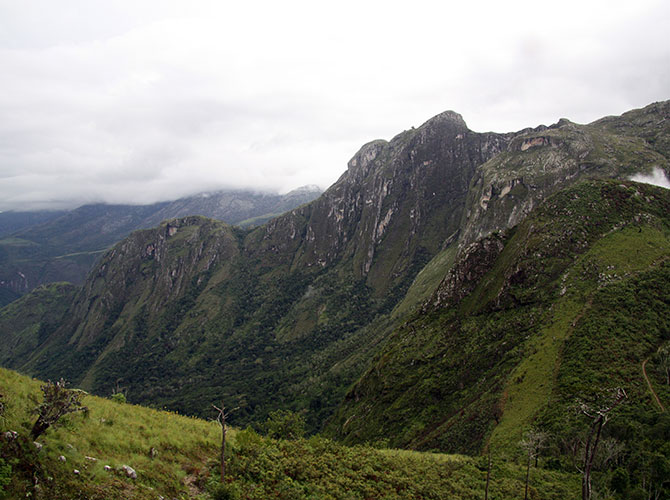
Mount Mulanje is the highest massif in Malawi and is found in the south-eastern corner of the country. It covers an area of 650 square kilometres and is known as the ‘Island in the Sky’ by locals.
Mulanje boasts over fifty peaks that attain an altitude greater than 2,000 m rising from the surrounding plateau including “Green Horror”, “Slug”, “Scorpion” and “The Turd”. The highest peak in the massif is Sapitwa which in Chichewa means “the place where one must not go”. It is also the highest peak in Central Africa reaching 3,002 m above sea level.

Above: Cyperus spissiflorus. Photo © Zoë Chapman Poulsen.
After defeating hordes of angry ants while repacking our bags ready for departure, we began the long and hot ascent up to our first overnight stop at the eponymous Chambe Hut, named after the peak over which it looks, home to the largest rock face on the African continent.
It was the peak of the wet season with temperatures clocking in at more than 40°C. The air was so humid it felt like breathing underwater as we struggled upwards along sticky and slippery orange clay paths that were almost vertical at times. A little relief came during the regular river crossings, one of which involved me being lowered by the arms over a huge and slippery granite rock face into the water.
Exhaustion set in, to the point of struggling to put one foot in front of the other and the intense heat made the climb feel impossible to achieve. But little by little the plains below grew more distant below us and the vegetation slowly changed as we climbed upwards.
Eventually, around five hours later we reached the top of the plateau and cooling mist swirled around us. Onwards we trudged getting wetter and colder by the moment. Suddenly the mist cleared as we rounded the next corner to reveal the face of Chambe Peak and our beds for the night.

Above: Protea caffra ssp. nyasae growing in habitat context (Chambe Peak in the background). Photo © Zoë Chapman Poulsen.
The next morning dawned wet and misty and it was with more than a little trepidation that we packed up and headed out into the murk, feeling rather as though we were on a summer holiday in Scotland rather than between the tropics. But the weather gods were luckily on our side and the white-out subsided to reveal some of the most spectacular scenery of the hike.
The vegetation of the “Island in the Sky” is tremendously diverse and home to numerous endemic plants with 70 of the 1,330 species of vascular plants only occurring on the massif. This is owing to a complex mosaic of habitats created by high variation in levels of rainfall due to the influence of the Mozambican trade winds. Rainfall varies from 2,859 mm/yr on the south-eastern plateau around Lichenya to 2,001 mm/yr on Esperanza Tea Estate at the base of the mountain.
The majority of endemic species on Mount Mulanje are herbs, grasses or small woody plants which occur in high altitude grassland, shrubland or rocky terrain (<1,750 m asl). We were warned that this wasn’t the best time of year to hike the massif owing to the often inclement weather but our efforts were rewarded by seeing some stunning species at their peak flowering times.
This included the endemic Streptocarpus nimbicola which only flowers from December to February, growing on wet moss-covered rock faces, in crevices and at the base of tufted sedges. Other endemics we spotted along the way included Cleome densifolia, Senecio whyteanus and Cyperus spissiflorus. The latter could be easily identified by the inflorescences of light brown congested spikelets that typify the species.

Above: After the storm: View over Lake Chilwa with Mozambique beyond. Photo © Zoë Chapman Poulsen.
We were also treated to the magnificent sight of the Mulanje endemic subspecies Protea caffra subsp. nyasae growing in the montane grasslands on the plateau. It was also in full flower and being visited at regular intervals by Southern Double-Collared Sunbirds which are a key pollinator.
We reached Chisepo Hut on the lower slopes of Sapitwa in the early afternoon but unfortunately due to cloud around the peak conditions weren’t suitable to attempt an ascent. We decided to push on to Sombani Hut, our final destination on the Mulanje Plateau.
Unfortunately, flash flooding is common on the Mulanje Massif during the rainy season. Reaching Sombani Hut safely depended on crossing three large rivers, none of which had any form of bridge.
We crossed the first and second river without incident, but taking note at the second river of the huge boulders brought down by floodwaters past giving clues as to how intense the flow could become. Just after we crossed the second river cloud started to swirl around Sapitwa high above us and huge raindrops started to fall from the heavens.
We realised that we were going to be in serious trouble if we didn’t take action fast. We were still too far from the third river to reach it and cross safely and we were in very real danger of being trapped overnight on the mountain between two raging torrents if we proceeded forwards.
If we retraced our steps immediately we were still in with a chance of getting back across the other two rivers before they became too swollen to cross. So far so good with the first return crossing, which passed with ease and without incident.
Unfortunately, our proximity to the last river before Chisepo Hut was heralded by a deafening roar of water. As the white rushing torrent came into sight we realised we needed to move quickly if we were going to stand any chance of crossing safely.
A branch pushed into the water revealed that we could still just about cross safely with care, being called by the warm cosy hut waiting for us just a few metres away from the other side. I took a step into the water and immediately felt the current pulling my legs from underneath me. Falling was not an option as the crossing point was immediately above a large waterfall.

Above: View of Namasile Peak from Sombani Hut. Photo © Zoë Chapman Poulsen.
With no time to think I was grabbed by several of the stronger guys and we clung to each other and slowly edged across through the torrent. It was about thigh deep but the current was extremely strong and the river bed was too rocky to easily find a grip.
I remember screaming most of the way across as my rucksack and I were pulled like a ragdoll by strong climbers through the water. It was with the deepest relief that we safely reached the other side. The warm fire in the hut that night was beyond cosy and welcoming as we lay huddled like penguins around the fire listening to the rain hammering against the tin roof.
The following morning dawned bright and clear. With the previous day’s storm seeming akin to a distant past nightmare we looked out of the hut door and down over the surrounding landscape far below. The light glinted on the water of Lake Chilwa and we could see as far as Mozambique beyond. We quickly packed up and headed on our way and soon arrived at Sombani Hut without incident.
The path took us through some spectacular grasslands full of flowering orchids. I enjoyed some precious downtime after the trauma of the previous evening but the more energetic members of the group climbed Namasile Peak after we arrived. From this lofty perspective, one can see the whole of the Mulanje Massif and the others returned later triumphant if rather tired after the climb.
After our final night on the plateau, we carefully slithered and slid our way down from the plateau down through the slippery clay maze of paths once more. Eventually, we reached the base of the massif and piled into a minibus taxi back to Likubula Village to retrieve our trusty steed. We were hemmed into an ancient vehicle that had long since lost any functioning suspension along with numerous people, bags of mealies and the odd chicken or two.

Above: Augrabies Falls on the Gariep River during the biggest flood since the 1980s. Photo © Zoë Chapman Poulsen.
The next morning we headed up to the Lake for a couple of days of relaxation before we began the journey down southwards. After our experience of Beitbridge Border crossing, we decided to avoid it by travelling down through Botswana and crossing back into South Africa at Mafeking.
This was a pleasant and easy journey after the greater challenges we encountered heading northwards. After being stamped quickly and easily back into South Africa we headed westwards across North-West Province and into the Kalahari Desert.
We had heard rumours during our travels that Augrabies Falls on the Gariep River was currently experiencing the biggest floods since the 1980s and consequently it was on our route so we decided to make this our final night’s stop.
We weren’t disappointed. The spray from the falls was visible from more than thirty kilometres away and the flow was at 4,416 cumecs (cubic metres per second). We stood quietly overlooking the falls, cold beer in hand, cowering underneath our waterproofs in a futile attempt to remain dry. This was southern Africa’s nature at her most spectacular. Never will I forget it.
Find me on Instagram
Plant Information
Connect on Social
Connect on Facebook, Twitter and Instagram
Taking Action
There are many environmental organisations based in Cape Town and beyond that require the services of volunteers to undertake their work. So if you have a little time to spare please get involved.

